Cycling the Col du Galibier from Saint Michel de Maurienne: A Guide for Cyclists
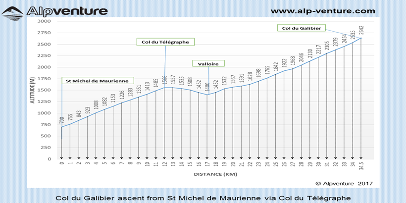
Col du Galibier climb profile
19-12-2025
The Col du Galibier is one of the French Alps' most iconic cycling climbs, featured regularly in the Tour de France and celebrated in the world of road cycling. The northern ascent, starting from Saint Michel de Maurienne, is renowned for its challenging gradients, scenic switchbacks, and high-altitude finish at 2,642 metres above sea level.
Overview of the Col du Galibier Climb
This epic route combines the ascent of the Col du Télégraphe with the Col du Galibier, offering a continuous climb packed with history and panoramic mountain views. Its reputation is matched only by its difficulty, with gradients that test cyclists’ endurance and grit.
Total distance (one way): 35 km
Start altitude: 710 m
Highest point: 2,642 m
Start location: Saint Michel de Maurienne, Savoie, France
Gradient and Profile Details
Overall average gradient: 5.5%
Saint Michel de Maurienne to Col du Télégraphe: 7.3% average
Valloire to Col du Galibier: 7% average, with some steeper sections up to 10%
Step-by-Step Route Description
Begin on the main street of Saint Michel de Maurienne (road D1006), turn right onto D902, and follow signs for Valloire, Col du Télégraphe, and Col du Galibier.
The ascent to Col du Télégraphe is a steady ride along a mostly tree-lined road, providing some shade in summer. The climb averages just above 7%, and a restaurant awaits at the top of the col if you need a break.
After topping out at Col du Télégraphe, enjoy a 4 km descent into Valloire. This Alpine town is an ideal place to refuel, with several restaurants and shops on offer.
Leaving Valloire, the road climbs gently for the first 5 km, then gets steeper with gradients between 7% and 10%. Water sources are available along the road, with the last one roughly 8 km below the summit at a mountain refuge.
Approaching the top, cyclists will notice a road tunnel through the mountain. For the true Galibier experience, take the left road before the tunnel to finish at the summit. This final ramp can be closed early or late in the season depending on snowfall—always check local advisories before your ride.
Restaurants/snack bars are located near the summit from both the north and south sides, providing additional opportunities to rest and refuel.
From the summit, it’s possible to descend southwards to Col du Lautaret (2,058m), with further options to continue towards Briançon or head towards Le Bourg d’Oisans.
When to Ride and Seasonal Advice
The road over the Col du Galibier is typically open from late May or early June until the end of October, although the exact season depends on snow accumulation and mountain conditions. If planning an early or late season ride, always check the latest road status online or locally before attempting the climb.
Tips for Cyclists
Start early in the day to avoid the heat, especially for the initial, shaded sections.
Carry sufficient water and snacks, even though there are some water sources and refreshments available along the way.
Weather can change rapidly at altitude—bring layers and be prepared for cooler conditions at the summit.
The road is usually open from late May or early June until late October, depending on snowfall. Always check the latest updates before you travel.
Is water available on the Col du Galibier route?
There are water sources on the route, with the last one at a mountain refuge about 8 km below the summit. Still, carrying extra water is advised.
Can I find food or drinks en route?
Yes, restaurants and snack bars can be found at the top of Col du Télégraphe, in Valloire, and near the summit on both sides of the Col du Galibier.
How hard is the climb from Saint Michel de Maurienne?
This north-side ascent is considered challenging due to its length, sustained gradients, and high altitude. The route features several sections with gradients above 7%.
How do I arrange transfers or bike transport to the area?
Private transfers are available from Alpine airports and train stations. For routes via Grenoble, Lyon or Geneva, consider booking with a dedicated transfer company for convenience and bike-friendly services.
Discover the best ways to travel from Grenoble and Lyon Airports to French Alps ski resorts. Get information, transfer tips, and advice for a smooth journey.
I cannot thank you enough for the brilliant communication and excellent service that you gave all my family in such difficult weather and traffic conditions.
Fantastic value for money!
Adam
Excellent transfer company
Everything done brilliantly. Booking was quick and easy, communication regarding pick up excellent. Liveried 8 passengers in a clean vehicle.






 Royalty
